|
|
| Hilo Magazine - Nature Reserve, Hilo, Big Island, Hawaii |
| Hilo, Hawaii |
|
Mauna Kea Ice Age Natural Area Reserve |

|
|
Sparsely vegetated cinder and lava deserts on the southern summit flank of Mauna Kea include two rare communities: an invertebrate-dominated aeolian desert and the state's only alpine lake. Important archeological and geological features are also present.
|
| Hilo, Hawaii |
|
Kipuka Ainahou State Nene Sanctuary |
 |
|
Kipuka Ainahou State Nene Sanctuary was officially established in 1974. The Kipuka Ainahou State Nene Sanctuary has about 38,000 acres. The Kipuka Ainahou State Nene Sanctuary extends from Saddle Road to the flank of Mauna Loa on State owned land. Elevation is between 6,000 and 9,000 feet above sea level. |
 |
| Hilo, Hawaii |
|
Laupahoehoe Natural Area Reserve |
 |
|
On the slopes of windward Mauna Kea, Laupahoehoe includes examples of wet montane forests of `ohi`a and koa. The poorly drained portions contain wet grasslands and small montane lakes. Numerous streams run through the Reserve. Laupahoehoe is located in the North Hilo District on the island of Hawaii, and stretches from just above 1,600 feet to about 4,600 feet elevation. Hakalau National Wildlife Refuge is adjacent to Laupahoehoe Reserve, and protects habitat for several endangered forest birds known to occur in Laupahoehoe as well. Five native natural communities can be observed in the Laupahoehoe Reserve, including a tall-stature koa/`ohia forest in both montane and lowland zones, `ohia/hapu`u (Cibotium spp.) forest, Carex alligata wet grassland, and non-native dominated patches. |
 |
| Hilo, Hawaii |
|
Hakalau Forest National Wildlife Refuge |
 |
|
Hakalau Forest was established in 1985 to protect and manage endangered Hawaiian forest birds and their rain forest habitat. Located on the windward slope of Mauna Kea, Island of Hawai‘i, the 32,733-acre Hakalau Forest Unit supports a diversity of native birds and plants equaled by only one or two other areas in the State of Hawai‘i. Eight of the 14 native bird species occurring at Hakalau are endangered. Thirteen migratory bird species and 20 introduced species, including eight game birds, as well as the endangered ‘ope‘ape‘a (Hawaiian hoary bat) also frequent the refuge. Twenty-nine rare plant species are known from the refuge and adjacent lands. Twelve are currently listed as endangered. Two endangered lobelias have fewer than five plants known to exist in the wild. |
 |
| Hilo, Hawaii |
|
Kipuka Puaulu ( Bird Park ) |
 |
|
Kipuka is surrounded on all sides lava flows. Left undisturbed for a long time, an ecosystem, such as that a Kipuka Puaulu, forms. Puaulu, also called Bird Park, is an old ohia tree and fern forest which is home to many of the feathered residents of the Big Island. A 30-minute stroll along this 1-mile trail will reveal several different high elevation birds, including the colorful Khalij Pheasant. Kipuka Puaulu is located in Hawaii Volcanoes National Park on Mauna Loa Road just outside the park gate. It is located 1.5 miles up the road, just past the tree molds. Kipuka Puaulu Bird Park is located in the Volcano |
| Hilo, Hawaii |
|
Kahaualea Natural Area Reserve |
 |
|
Kahauale`a includes representatives of pioneer vegetation on lava flows, lowland rain forest and mesic forest in the Puna District. It includes the largest known populations of a federally endangered fern, Adenophorus periens, as well as the currently active flows of the Pu`u O`o vent |
 |
| Hilo, Hawaii |
|
Waiopae Tidepools Marine Life Conservation District |

|
|
Located on the Southeastern coast of the island of Hawai`i, the Waiopae Tidepools MLCD is about a one hour drive south of the Hilo airport. Take highway 130 heading south, then go east on highway 132 to highway 137. Travel about 1.1 miles south on highway 137 and turn east on Kapoho Kai drive. Follow road to parking areas marked by signs.
The MLCD is located adjacent to a private subdivision called Vacationland. Follow directions to all signs posted; enter tidepools only at the designated shoreline access and respect private property. The MLCD extends from the highwater mark at the shoreline, with the northern boundary next to the first two-story house on the beach north of the parking area, and extends south about 700 meters. Signs mark the boundaries.
|
 |
 |
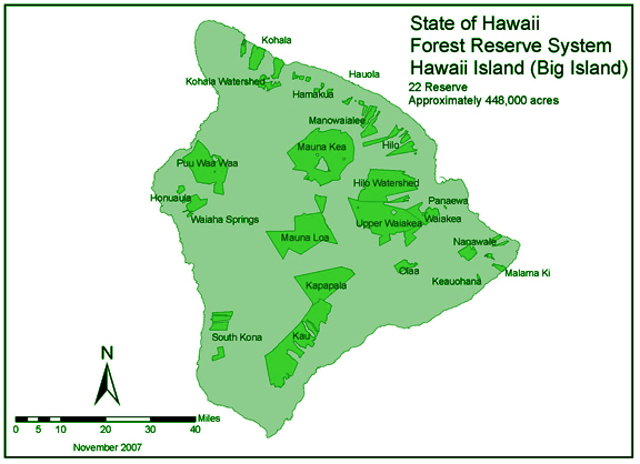
| Hamakua Forest Reserve |
| Hauola Forest Reserve |
| Hilo Forest Reserve |
| Hilo Watershed Forest Reserve |
| Hauola Forest Reserve |
| Malama Ki Forest Reserve |
| Manowaialee Forest Reserve |
| Mauna Kea Forest Reserve |
| Nanawale Forest Reserve |
| Olaa Forest Reserve |
| Panaewa Forest Reserve |
| Upper Waiakea Forest Reserve |
|
|
|


